Recent work
Sundowner winds
Sundowner winds are the local name of downslope windstorms in coastal Santa Barbara, CA. They have intensified all major wildfires in SBA. A better understanding of these winds leads to better predictions and a more resilient society. We have published several papers on downslope windstorms and wildfire spread using numerical modeling and observational approaches:
Sundowner winds are the local name of downslope windstorms in coastal Santa Barbara, CA. They have intensified all major wildfires in SBA. A better understanding of these winds leads to better predictions and a more resilient society. We have published several papers on downslope windstorms and wildfire spread using numerical modeling and observational approaches:
- Sundowner winds field EXperiment, (Carvalho et al. 2024)
- Impact of heatwaves on wildfire risk (Duine et al. 2022)
- Diurnal variability of Sundowner winds (Duine et al. 2021)
- WRF sensitivity study to simulations downslope windstorms (Duine et al. 2019)
- Sundowner winds EXperiment (SWEX) pilot study (Carvalho et al. 2020)
- Wildfire spread during downslope windstorms: Zigner et al 2020; Zigner et al. 2022
|
Heatwave Impacts on Wildfire Risk
This study examines two severe heatwaves in Santa Barbara County, California. The first, in July 2018, triggered a wildfire due to high temperatures, low humidity, and strong winds, exacerbated by mountain wave activity. These strong winds are locally known as "Sundowner winds". The second, in September 2020, set all-time temperature records at ten stations but had weaker winds. Despite this, the extreme heat and low humidity briefly elevated fire risk. A novel diagram was created to assess the joint impact of temperature, humidity, winds, and the Fosberg Fire Weather Index (FFWI). While no wildfires occurred during the 2020 heatwave, the analysis suggests that combining extreme heat with stronger winds could lead to unprecedented fire danger, an increasingly likely scenario in a warming climate. |
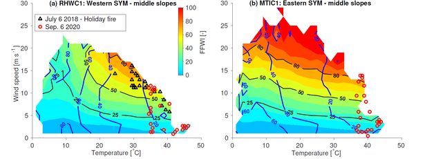
Climatology of fire weather index FFWI (colored contours, dimensionless) and relative humidity (blue contours, in %) as a function of temperature and winds for two distinct surface stations in the Santa Ynez Mountains, California. The panels show hourly observations of temperature, winds and wildfire risks (FFWI) in these two locations. These diagrams are useful in contextualizing the relative severity of meteorological conditions and wildfire risk during two extreme heat waves: July 6, 2018 (black symbols) and September 6, 2020 (red symbols). Unfortunately, the MTIC1 did not report data for the September 6 2020 event. From Duine et al. 2022.
|
|
Diurnal variability of Sundowners
Sundowner winds are among the few downslope windstorms that undergo a remarkable diurnal variability, with strongest winds during the nighttime. Typically, the onset is in the period from late afternoon to early evening, hence, the name Sundowners. Using the Weather Research and Forecasting model, we have studied what drives this diurnal variability. By removing the terrain upstream of the Santa Ynez Mountains, we showed that the Sundowner diurnal cycle during the eastern regime can be explained by boundary-layer processes in the valley and the blocking effect of the higher San Rafael Mountains upstream of the SYM. These results contribute to a better understanding of the influence of upstream orography in the cycle and intensity of downslope windstorms in coastal mountains. |
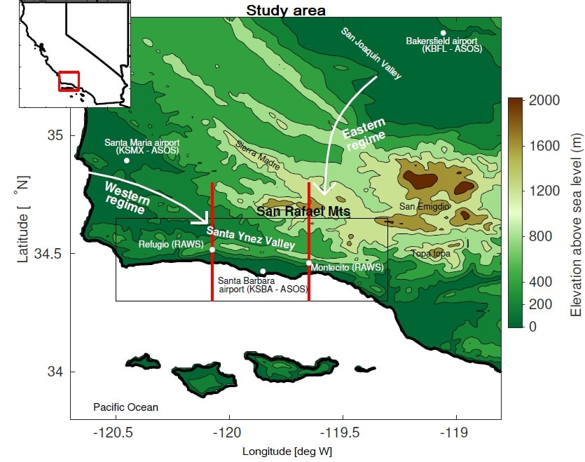
Study area highlighting western and eastern regime larger-scale flows, and relevant topography. From Duine et al. 2021
|
|
Convective boundary layers in complex terrain
We have assessed the impact of grid spacing on convective boundary layer depths over a variety of terrain, climate zones, grid spacing and PBL parameterizations. We found that that the coarser grid can produce significantly deeper convective boundary layers, particularly over mountaintops, resulting in average biases of 10%, but occasionally reach 25%. We attribute this to terrain smoothing, which is a direct consequence of the grid spacing used in the numerical model. Our findings are relevant to applications that rely on a correct estimation of the planetary boundary layer, including climate research, PBL evaluation studies, greenhouse gas budget estimations and integrated water vapor transport studies, air quality applications, planning and executing prescribed burns, and studies associated with precipitation over mountainous terrain. |
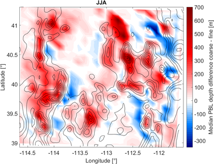
Median differences in afternoon PBL depths for summer months in Utah, 10 km minus 3.3 km grid spacing. Thin solid lines represent terrain elevation of the fine grid domain (contour line interval is 200 m). From Duine and De Wekker (2017).
|
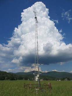
Field work
I have participated in and co-organized several field campaigns:
Sundowner Wind EXperiment (SWEX),
Santa Barbara CA (Spring 2022)
Pilot SWEX, Santa Barbara CA (Apr. 2018)
Solar eclipse experiment 2017, Innisfree, VA (Aug. 2017)
KASCADE 2013, France (winter 2013)
I have participated in and co-organized several field campaigns:
Sundowner Wind EXperiment (SWEX),
Santa Barbara CA (Spring 2022)
Pilot SWEX, Santa Barbara CA (Apr. 2018)
Solar eclipse experiment 2017, Innisfree, VA (Aug. 2017)
KASCADE 2013, France (winter 2013)
|
Current position:
Project Scientist, Earth Research Institute, University of California, Santa Barbara, California. Nov. 2020 - current Previous positions: Postdoc, Earth Research Institute, University of California, Santa Barbara, California. Feb. 2018 - Nov. 2020 Advisers: Leila MV Carvalho and Charles Jones Postdoc, Dept. of Environmental Sciences, University of Virginia, Charlottesville, VA. Mar. 2016 - Jan. 2018. Adviser: Stephan FJ De Wekker Education: PhD Meteorology, University of Toulouse, France MSc Meteorology & Air Quality, Wageningen University, the Netherlands BSc Soil, Water & Atmosphere, Wageningen University, the Netherlands |
|
|
|
